


Using Lasers & Mining Data
By Ben Verde & Brandon Mikesell
How can you confirm if an exit is jumpable? "How do I know if I personally can do it??? This seems a bit dodgy, at best."
We have all felt this way before. In the past, we jumpers have had few tools for understanding the relationship between our capabilities and the unknown. We relied on anecdotal input from friends, or present company, and then we’d imagine being that rock that was just thrown from the exit point into the void. This usually resulted in more questions, or maybe the vague sense of "I got this." However, the future is now. Digital data collection is the current best method of interpreting the time and space that makes up the void, giving us a glimpse of what we might reasonably expect to experience, should we be willing to huck our meat.
The two primary components needed for this method of data collection are a GPS, and a laser. The GPS gives us a sample of our personal performance at known exit points. A laser allows us to measure the actual terrain in front of us.
Must Have: FlySight or XGPS160.
Using a GPS will allow you to collect the data sample of exactly how you perform, from your best to your worst. You will gain insight into facets of your jumping such as separation from the object, wingsuit or tracksuit start arc, suit glide capability and canopy glide capability, just to name a few. This device is turned on before flight and records it's speed and location until it's turned off again. Once in front of a computer you can access the data log that shows a reasonably accurate depiction of what happened during your jump. This can be used to confirm what you thought happened and potentially reveal additional insight that may have been missed or overlooked.
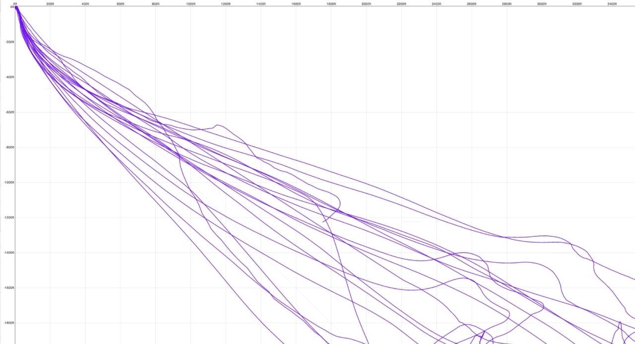
These devices are usually paired with difficult to understand and often confusing charts, graphs and number sequences but don't give up just yet. https://Baseline.ws is here to help simplify this and store your data for easy access. Simply sign into the website then drag-and-drop your data tracks for easy to read depictions of your jumps. You can view a side profile of your jump from exit to landing or pinpoint exact speed, glide or distance from any one moment during your flight. The value of this Insight is immeasurable but the specifics are very measurable. Once you start to see a pattern emerge then "I think I can" may become "yes I can with x amount of margin." You can also confirm "I'm not ready yet."
Once you've recorded multiple base jumps on a suit and uploaded them to Baseline.ws, you can see the range of your start performance using the "profiles" page.
Your data may reveal impacting 4 out of 10 times which would support a statement such as, "I'm not ready yet."
Beyond the "can or can't" is the potential to begin understanding the relationship between your average performance in the effects of weather conditions on your performance during your jump. You may find you can do a jump 10 out of 10 times successfully but it only takes slightly less-than-ideal conditions to significantly increase the chance of an accident. This tool is a must for self reliability. You alone are responsible for your actions and choices.
The second tool is a Laser Rangefinder. Must Have:
Rangefinder: Trupulse 200l Forestry Pro
Rangefinder with bluetooth: Unieye, ATN and Sig Saurer
I personally use a forestry rangefinder called the Trupulse 200l. I have also enjoyed the Unieye and its ability to connect to my phone and Baseline.ws app via bluetooth. The way the rangefinder is used and the data collected is organized will simplify interpreting the data. Messy and disorganized data will prove to be useless and cause further confusion. I record two sets of data when I scout a new exit. The first set is a very simple and basic side profile view of the exit and terrain below. The purpose of this is to determine the path of least resistance in relation to where I might find myself if things are barely working out. If I am comfortable with flying my suit, body or parachute in a particular location along a potential flight path then I can consider that location as part of the path of least resistance. The path of least resistance is your worst case scenario performance compared to your performance mandatory checkpoints along your potential flight path. You must have a large measurable margin between this data set and your personal collection of experienced capability data (your flysight data collection).
The path of least resistance is simply the mandatory performance checkpoints of a given exit and its subsequent terrain in as straight of a line as possible.
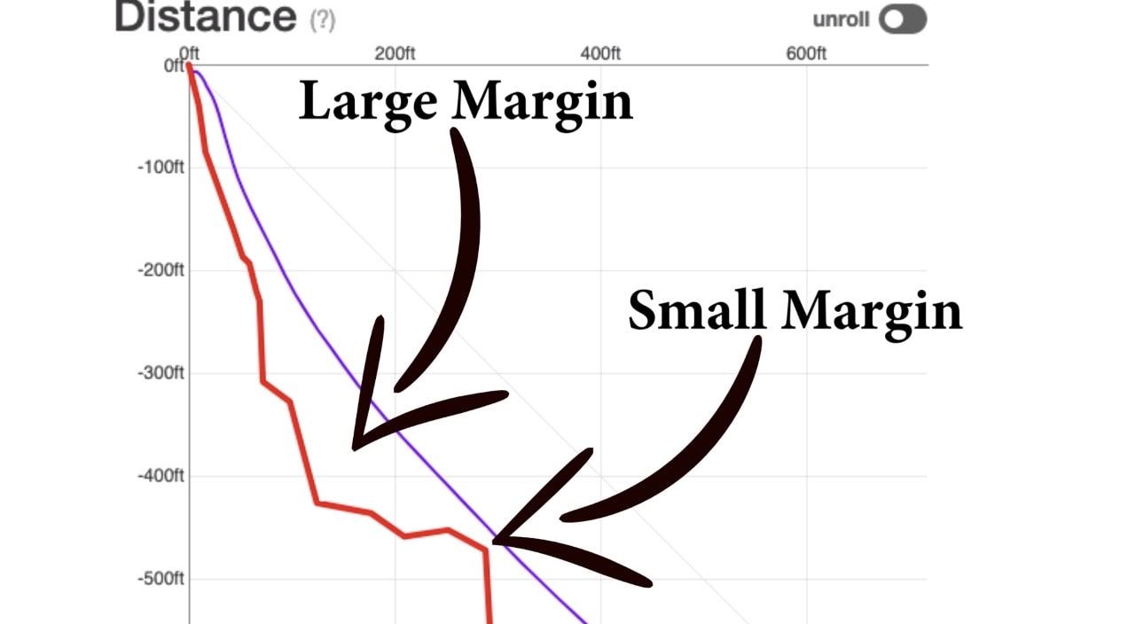
These checkpoints are usually ledges and outcroppings (coincidentally, the places you might impact). They are measured in feet or meters as -Down/out. For example, if I jump here I will need to clear that ledge. Once I pass that ledge, I am safe. The furthest part of that ledge measures -362/69 feet. In this case the performance mandatory is a ledge that extends to 69 feet out from the exit at 362 ft below the exit. Simply, you will need to be further than 70 feet away from the exit by the time you have fallen 360 feet, if you want to clear that particular ledge.
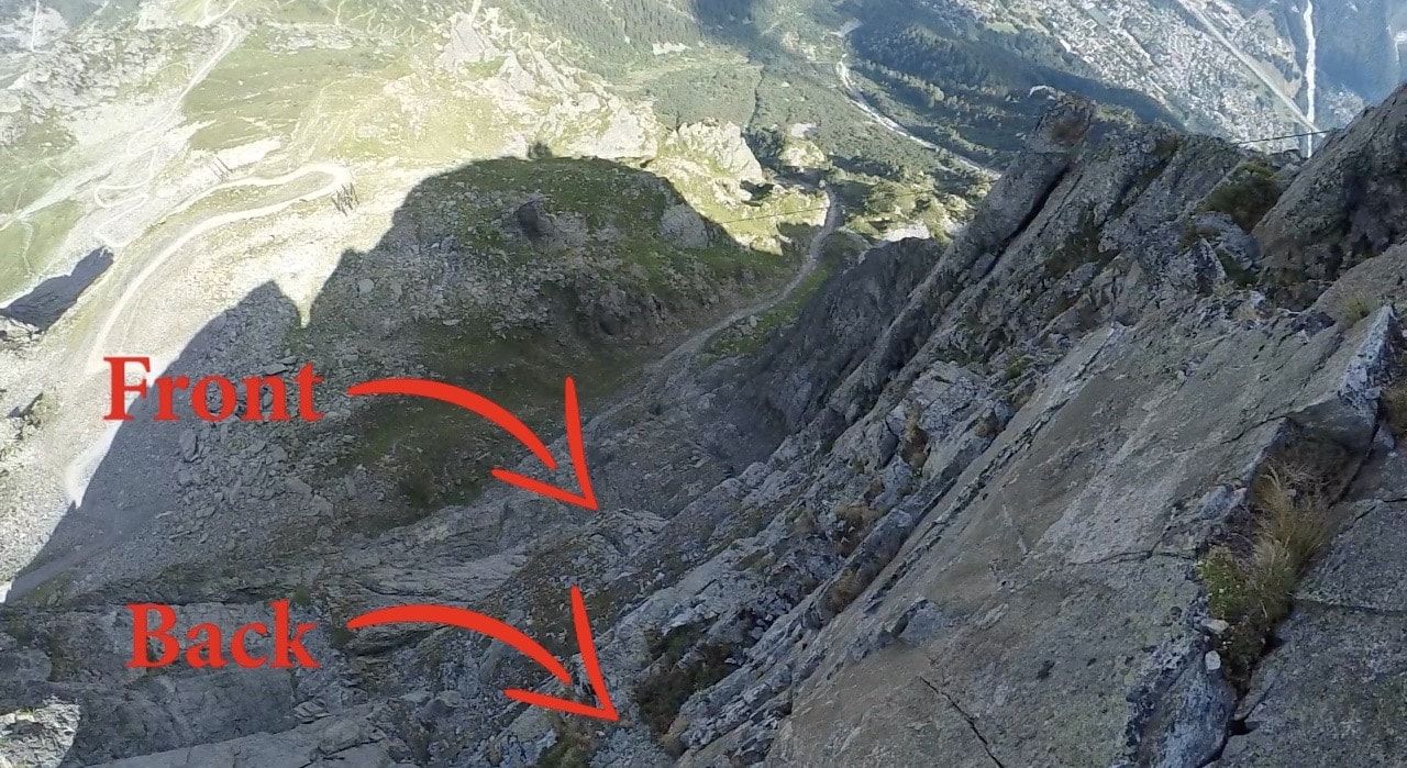
To obtain the most accurate side profile model you will need to measure a second set of data. Shoot both the back and front of each feature. Again, keep your data points in a straight line for the most accuracy. Shooting the back (closest to you) of each ledge and the front (furthest visible point from you) will provide you with the most detailed side profile of your cliff. Record your data in order from the exit down to the LZ. Here's an example
- 411/6ft
- 490/160ft
- 680/380ft
- 795/576ft
- 880/780ft
- 1040/1275ft
- 1335/2121ft
- 1300/2300ft
By understanding how to use your laser and interpret the data recorded on your previous jumps you will be armed with the resources needed to make decisions based on both mathematics and scientific reasoning. These tools combined with a slow progression and eagerness to learn will help to achieve a long satisfying base career. Keeping your laser data collection consistent will help you share laser data with others, allowing peers to make more complete assessments before even starting a hike.